 Tech Gadget Central Latest Tech News and Reviews
Methane leaks have gone unnoticed by authorities for an extended period. Can satellite tracking alter that?
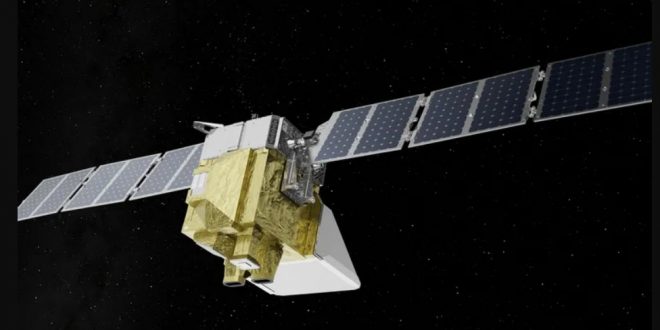
An effort to map and monitor worldwide methane pollution, a potent greenhouse gas, is set to commence today after years of cooperation among major tech companies. MethaneSAT is a satellite that has received money and support from Jeff Bezos, Google, and SpaceX, among others.
MethaneSAT is scheduled to be launched today from Vandenberg Space Force Base in California on a SpaceX Falcon 9 rocket at 2:05 PM PT. The launch will be broadcast live on the SpaceX website and the company’s X profile. The Environmental Defense Fund, creator of MethaneSAT, will host a special event at 1:40 PT, including important experts and supporters discussing the project.
Approximately 30% of global warming, leading to rising sea levels and more severe weather events, is attributed to methane emissions. Waste decomposing in landfills, methane-producing bacteria in rice paddies, and most notably cattle producing methane through burping and defecating all contribute to the production of gas. It often leaks from oil and gas fields, pipelines, and household appliances. Essentially, natural gas is mostly composed of methane.
The Environmental Defense Fund (EDF) aims to address the issue of leaking gas via MethaneSAT. The organization has already recorded significant quantities of methane leakage. From 2012 to 2018, it was found that US methane emissions exceeded the Environmental Protection Agency’s forecasts by 60 percent.
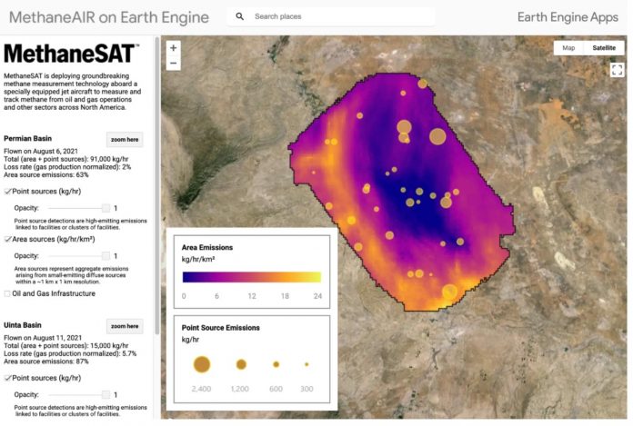
The organization collaborated with 40 academic institutes and 50 enterprises to get a more detailed overview of methane emissions. Data collection included meticulous efforts to gather measurements from pollution sources on the ground and aerial readings obtained from airplanes.
MethaneSAT has a higher coverage rate and quicker speed. According to EDF, surveying the same region should only take approximately 20 seconds, but it would have taken an airplane two hours to do the same. Traveling around Earth in 95 minutes, it will monitor oil and gas fields responsible for over 80% of worldwide output.
The objective is to promptly identify the amount of methane being released and its sources in order to take action to seal such leaks. Methane is 80 times more effective than carbon dioxide from burning fossil fuels in terms of global warming potential; however, this effect diminishes within the first 20 years of being released into the atmosphere.
Carbon dioxide remains in the atmosphere for an extended period of time and retains heat for millennia. Preventing methane leaks is considered a rapid method to have a large and immediate impact on climate change due to its potency as a greenhouse gas with a short lifespan.
Last month, Google and EDF revealed a collaboration to develop a worldwide map of methane emissions from oil and gas facilities. The business is using artificial intelligence to detect well pads, pump jacks, and storage tanks in satellite images, similar to how it recognizes sidewalks and street signs for Google Maps. Aligning the infrastructure with emissions data from MethaneSAT might assist authorities in identifying leak locations.
If this mission is successful, it might revolutionize the way politicians evaluate progress on climate action by using real-world pollution data instead of relying on corporations’ self-reported emission estimates.
Mark Brownstein, EDF senior vice president of energy transition, stated during a press briefing that field measurements show industry emissions are higher than reported through engineering calculations.
According to EDF, the cost of the satellite’s construction and deployment was $88 million. In 2020, The Bezos Earth Fund provided a $100 million contribution to EDF to support the launch of MethaneSAT, establishing itself as one of the project’s primary financial supporters. MethaneSAT is the first government-funded space mission of New Zealand’s Space Agency.
MethaneSAT is expected to begin publicly sharing data by early summer if all goes as planned. A comprehensive overview of significant oil and gas basins worldwide is anticipated by 2025, with data that EDF said will be accessible on MethaneSAT’s website and Google Earth Engine.